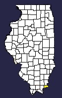
Usually, up until 1814, there was little clearing of land by settlers; for not until 1812-14 could land be bought in Southern Illinois, the settlers being squatters allowed by the government to remain upon the land, but with no rights of possession.
However, in 1814 a government land office was established in Shawneetown. There land was sold in quarter sections: first at public auction; or when no bidders were found, later on at a minimum price of $2.00 per acre, payable in installments over a three-year period. An 1818 land-plat map shows almost all Hardin County land bordering the Ohio had been taken up. In addition there was a large block taken out along Big Creek and other blocks near the mouth of Saline Creek, in the Harris Creek bottoms, and at Karber's Ridge.
In that year it is estimated that four hundred to five hundred people must have lived within the present boundaries of Hardin County — a well settled region for that time. Yet even ten years earlier the county had been settled along the river banks. This is described in the journal of Fortesque Cuming, who made a flatboat trip down the Ohio in 1808. Here, several paragraphs arc devoted to the region between Diamond Island, below Evansville, and Fort Massac, all of which is connected with Hardin County history.
Extracted from History of Hardin County, Illinois, written in 1939 by the Committee for the Centennial, pages 31-32.
| Saline | Gallatin | Union KY |
| Pope |
 |
|
| Livingston KY Crittenden KY | ||


